The Department of Aviation (1982-87) produced this 'Information Paper' on the use of radar in Air Traffic Control (ATC). Although it is somewhat shaky on the early history of radar, it is of historical interest because of its descriptions of how the system worked during the 1960s, 70s and 80s.
In the late 1980s the 'Bright Display' radar systems described here began to be replaced with fully synthetic display equipment (e.g. ATCARDS). From the early 1990s primary radar coverage was reduced, and secondary radar coverage extended. And although radar is still very much a part of ATC, from the turn of the century the computerised TAAATS equipment brought the era of paper strips to an end in ATC Centres.
In the mid 1930s British and American scientists were experimenting with
devices to locate objects such as ships and aircraft by the reflection
of radio waves directed by a rotating aerial. The process was originally
called radio location, but as experiment after experiment proved successful
a more elaborate name was chosen - "Radio Direction And Ranging",
which lent itself to the formation of a new word "RADAR".
Under the threat of World War II, radar was intensively developed to serve as a means of warning of the approach of hostile aircraft. During World War II tremendous advances were made in the use of radar for accurate anti-aircraft gun laying and ranging, the navigation of ships and aircraft, the location of enemy bomber forces, and for the direction of protective fighter aircraft to intercept and engage bombers long before they reached their target.
Despite the obvious non-military application of radar to civil Air Traffic Control, some years elapsed after the close of World War II before radar assumed a major role in civil aviation. The time lag was due to the need to design systems and equipment to meet the vastly different requirements of civil Air Traffic Control - requirements based on safety standards far and above those dictated by military needs in wartime.
One of the functions of Air Traffic Control is to ensure the safety of all aircraft movements in controlled airspace throughout Australia by the application of positive separation and to ensure their orderly progress in daily operations.
Air Traffic Control must accomplish this task with a minimum of interference to the economic operations of airline companies and individual aeroplanes. The system used for Air Traffic Control in Australia is based on certain procedures and rules compulsorily followed by pilots and Air Traffic Controllers - these rules include rigid separation standards which determine the minimum distance permitted between aircraft in all directions so that each aeroplane continues to fly in its own protected envelope of airspace.
These separation standards are applied in all instructions which permit aircraft to depart, climb, cruise, change altitude, descend, approach and land.
The information requested for these purposes is obtained from the flight plan submitted by the pilot-in-command prior to the aircraft’s departure, and the pilot’s radio reports of the aircraft position and altitude after it becomes airborne. This information is recorded on specially printed cardboard strips called ‘flight progress strips’ which are held in plastic strip holders and displayed on a working console divided into bays, each representing a compulsory reporting point, landing aerodrome or departure point. The information noted on the flight progress strips includes the aircraft’s radio call-sign, flight number, departure point, route and destination, speed and altitude together with its estimated time over each particular reporting point en route to its destination.
Pilots and Controllers communicate directly with each other by means of air-to-ground and ground-to-air radio. The working console is known as a Flight Progress Board and is manned by a number of Controllers in an Area Control Centre. These Centres which are located at all capital city aerodromes and some provincial cities throughout Australia also contain ground-to-air radio communication facilities, inter-unit radio, telephones and teleprinters and other necessary adjuncts to air traffic control.
Controlled airspace has been designated in each State of Australia, incorporating air-routes between the capital cities and main provincial centres. An aircraft must receive an Air Traffic Control clearance to fly in controlled airspace and these clearances are issued by the Air Traffic Controller manning a particular sector in the Area Control Centre, i.e. looking after a particular air route.
An aircraft
flying between Sydney and Melbourne is the responsibility of a certain
Sector Controller located at Sydney Airport until such time as it reaches
the Murray River, then it becomes the responsibility of a Sector Controller
in Melbourne. The Murray River in this case is the boundary of the controlled
airspace administered by Sydney and Melbourne.
Another Sydney Sector Controller is responsible for air traffic on the
Sydney-Brisbane-Sydney air routes between Sydney and Armidale - between
Armidale and Brisbane this traffic is controlled by a Sector Controller
at Brisbane Airport.
Various sectors are involved with a flight along an air route depending on the progress of the flight. An Enroute Sector Controller is responsible for an inbound aircraft from the boundary to within 90 miles from destination. At this point the aircraft is transferred to an Arrivals Controller who controls the aircraft during the descent phase until it is 30 miles from the aerodrome. Within 30 miles of each major airport, all air traffic, both inbound and outbound, is the responsibility of a control team known as Approach Control.
Co-ordination is one of the keynotes of Air Traffic Control, co-ordination between neighboring Area Control Centres, between each Area Control Centre and its Control Tower, and between each sector controller within the Centre.
This system, known as procedural control, uses separation standards based on vertical, longitudinal and lateral separation and has been developed and refined throughout the world during many years of use. It is a proven system because of the great safety margins built in to the separation standards and it functions well as long as the numbers of aeroplanes requiring to be controlled do not increase above a certain density.
In 1959 when the average week day air movements at Sydney and Melbourne Airports were approaching 200 - that is 60,000 movements a year at each airport, radar was installed which gave Air Traffic Controllers a continuous picture of all aircraft departing and arriving within a radius of 40 miles around each airport.
Initially, the information obtained from these radars was used to confirm the positions of aircraft as derived from the strip presentations and to monitor the separation standards already in use, however, a new breed of Air Traffic Controller was emerging - the radar controller.
While procedures and separation standards remained essentially unchanged outside the radius of radar coverage, the standards were reduced considerably within that 40 miles radius.
Outside the radius of radar coverage an aircraft had to be at least 20 miles ahead of another aircraft before it could descend through the following aircraft’s altitude - once inside the area of radar coverage, and after strict identification procedures were carried out by the Radar Controller, it was permissible for the aircraft under radar control to carry out the descent through a following aircraft’s altitude with separation on the radar screen of five miles.
At this time,
most airline aircraft had been equipped with D.M.E. (Distance
Measuring Equipment), which is an electronic device based on radar
principles, and which displays to a pilot in digital form, his distance
from a DME beacon. There are 120 such beacons along Australian air routes
and at each major aerodrome. Although DME made the Air Traffic Controller’s
task of determining aircraft positions more positive, he still had to
rely on pilot reports and the strip presentation for a composite picture
of all aircraft movements.
Radar with a 40-mile coverage around the aerodrome provided a pictorial
presentation of all aircraft movements - no longer was it necessary for
the descent of an arriving aircraft to be refused because of the presence
of’ another arriving aircraft underneath, but 14 miles behind; no
longer was it necessary for a departing aircraft to wait up to ten minutes
on the ground because it wished to climb above the cruising level of another
already established outbound to the same destination; no longer was it
necessary for aircraft wishing to land in bad weather to be stacked at
intervals of a thousand feet vertically over the final approach point
- radar controllers using the permissible five miles radar separation
standard alleviated all of these problems and more in the congested terminal
areas around Sydney and Melbourne airports.
Radar made
substantially more economic use of the airspace around the aerodrome and
resulted in fewer delays. It also provided positive knowledge, pictorially,
to Air Traffic Controllers. These two approach control radars as they
were called gave valuable service in the early 1960’s when air traffic
movements were increasing rapidly year to year.
The original installation of’ the two radar equipments was an interim
measure - their limitations having been foreseen. These limitations were,
broadly speaking, lack of range and the increasing workload on a single
Radar Controller attached to each Air Traffic Control Shift, and also
the need for radar at locations such as Brisbane and Adelaide. In 1961
the Department of Aviation produced a radar plan containing the recommendations
of an overseas mission which, in 1960, studied Air Traffic Control systems
in Britain, Holland, France and the U.S.A. As a result of this mission,
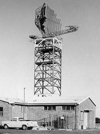
long range radars of an advanced design have now been installed at Adelaide,
Melbourne (Tullamarine), Perth, Sydney, Brisbane, Canberra and the New
England area of N.S.W. - each radar having a range of 160 nautical miles.
There is now an unbroken radar cover of the east coast air routes.
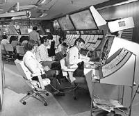
An entirely new concept of Air Traffic Control emerged as a result of the long range radar installations. Area Approach Control Centres (AACCs) were built at Brisbane, Sydney, Melbourne (Tullamarine), Adelaide and Perth which are the nerve centres of Air Traffic Control for each region. There is also an approach Control Unit at Canberra.
At least
two Air Traffic Controllers man each sector, one, the Procedural Controller,
having the responsibility for decision-making with reference to priorities,
separation standards and the safe, orderly and economic flow of air traffic;
the other, the Radar Controller, having the responsibility of implementing
those decisions by observing the air traffic on his radar screen.
The en route sector control radar screens have a range of 160 nautical
miles - outside that range, procedural separation standards are maintained.
Inside the area of radar coverage, however, all aircraft are continuously
radar-identified and the radar separation standard of five miles may be
employed at any time to solve such problems as aircraft wishing to change
altitude or direction.
When each aircraft in the arriving sequence approaches 30 miles the Arrivals
Radar Controller ‘hands off’ control and identification of the
aircraft to the Approach Radar Controller who, again using the five-mile
radar separation standard, integrates the arriving aircraft into an orderly
approach sequence for landing. The Approach Radar Controller is a member
of a three-man team manning the Approach/Departures Sector of the Area
Approach Control Centre. This sector, comprising an area of responsibility
of 30 nautical miles around the aerodrome, can best be described as the
‘Terminal Area’ where the movement of aircraft on radiating
arrival and departure tracks causes congestion which, before the introduction
of radar, would have meant comparatively long delays to air traffic movements.
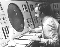
The Approach Radar Controller using a 40-mile bright display radar screen is seated alongside a Departures Radar Controller using a similar screen so that each observes the other’s traffic as well as his own. Departing aircraft are identified as soon as they become airborne. They normally receive a heading to fly determined by the Departures Controller in relation to the observed traffic on his radar screen and passed by the control tower to the pilot before his clearance for take-off.
The Approach
Radar Controller and the Departures Radar Controller work in an atmosphere
of close, face-to-face co-ordination, together with the third member of
the sector team who keeps the flight progress strip data display up-to-date
and who co-ordinates with the control tower the use of runways for departures
and landings, and weather observations.
The objective of the Departures Controller is to clear his aircraft in
a safe and orderly manner out of the terminal area and on to their particular
en route tracks where they may be ‘handed off’ to the relevant
en route Sector Controller. The duty of the Approach Controller is to
marshal his arriving traffic into a safe and orderly arrival sequence
and into a position where the pilot is established on a final approach
landing aid or is lined up visually with the landing runway. When within
10 miles of the aerodrome, the arriving aircraft are then transferred
to the control tower for a clearance to land.
The Terminal Area Radar Controllers (Departures and Approach) at Sydney and Melbourne, use 40-mile radius screens.
The long range radar aerial scans at five rpm, in other words, it constantly renews the radar picture provided to all controllers once every 12 seconds. However, increases in air traffic at Sydney and Melbourne particularly, brought the need for higher definition radar, capable of renewing its presentation at least once every 4 seconds. Accordingly the Department of Aviation installed high performance Terminal Approach Control Radars at Sydney and Melbourne (Tullamarine), and as the radar information could now be updated every 4 seconds, it was possible to reduce the radar separation standard to three miles. These radars serve the 40-mile radius terminal areas only.
The Department of Aviation has also implemented a further stage of its Radar Plan which is the installation at selected locations of Secondary Surveillance Radar which is not, as its name might suggest, a back-up or standby system for the primary radars already installed, although it may be used in conjunction with existing radars. SSR, as it is known, is a highly sophisticated system which depends for its operation upon the existence on an aircraft of a receiver/transmitter (transponder) which automatically responds to a recognised signal radiated from a ground station. Secondary Surveillance Radar when fully installed will provide the means by which an Air Traffic Controller will have automatically displayed to him information from an aircraft which he currently has to seek by radio communication. Such information as aircraft call-sign, altitude, speed and whether descending, climbing or cruising can be displayed automatically on a screen, together with the conventional radar ‘blip’.
These facilities enable Air Traffic Control to serve Australia’s highly sophisticated aviation industry with the highest standards of safety.
Examine a chart showing the extent of radar
coverage - 1967
Back to the main Air Traffic Services index page