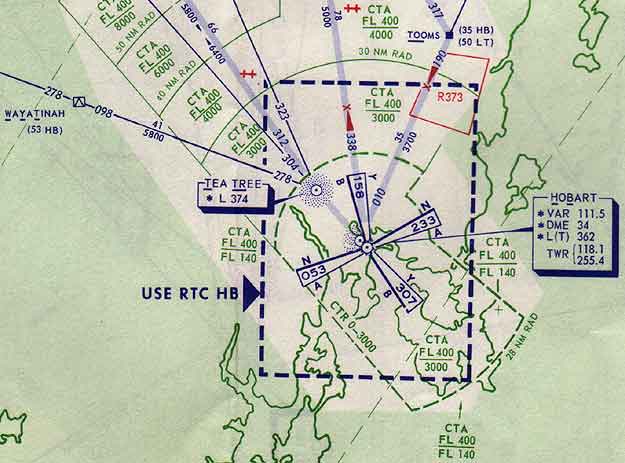
Two
of the last VAR beacons in service in Australia were at Devonport and Hobart,
Tasmania. This excerpt from Radio Navigation Chart 1 (AUS-RNC 1), dated 6 September
1979, graphically illustrates one of the main limitations of the VAR beacon, viz.
it's limit of four courses.
Although the courses could be, to some extent, 'bent' to align with a desired air route, the chart shows that three of the four courses of the Hobart beacon led to nowhere in particular. The only course aligned with an air route is the 158 degree course from Launceston. The 307 degree course was aligned with Runway 30 and could be used for an instrument approach.
Also worth noting is the large Control Zone (CTR), the generally low base of the Control Area (CTA) and the shallow CTA steps which were designed to accommodate the profiles of unpressurised aircraft.
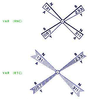
Left: This section from the Legend of AUS RNC 1 shows the symbols used to depict VAR beacons. The upper one is for Radio Navigation Charts (RNCs) and the lower for Radio Terminal Charts (RTCs). The present equivalents to these charts are the En Route Chart - Low (ERC-L) and Terminal Area Chart (TAC) respectively.
Both symbols clearly show the two visual courses (Blue and Yellow) and the two aural courses (Morse As and Ns) of the VAR beacon.
Click here to read more about VAR
(Chart: CAHS collection)
Back to the main Communications & Navigation index
If this page appears without menu bars at top and left, click here