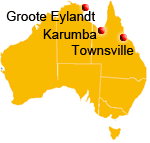
In 1938 DCA opened a new Flying Boat Base at Karumba, at the mouth of the Norman River in Queensland's Gulf of Carpentaria. The Base was a refuelling stop on the Empire Air Route from Australia to Britain, supporting the Empire flying
boat service operated by Qantas Empire Airways (QEA) and Imperial Airways Ltd (IAL). Click here to see a photo from the inauguration
of this service. The next stop to the west was at Groote Eylandt, then Darwin, while the next stop to the east was at Townsville (see map at bottom).
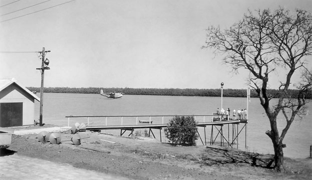
The photo above shows Short S.23 Empire flying boat G-ADUT Centaurus alighting on the Norman River at Karumba in 1938. Although British-registered, the aircraft was being operated by QEA. QEA operated the Sydney-Singapore legs of the Empire Air Route to Britain, and IAL operated between Singapore and the UK. However, the aircraft were interchanged between the two airlines at Singapore.
After alighting, the flying boats tied up at a mooring on the far side of the river, to be refuelled from a Shell fuel company launch. During refuelling, all passengers had to be brought ashore and had to climb up the ladder at the end of the jetty to the landing stage. They were then conducted over the base and given a 'cuppa'.
The objects at the land end of the jetty are flare buoys for laying a night flarepath. Although night flying as such was seldom practiced by the Empire 'boats, pre-dawn departures and after-dusk arrivals required a flarepath. This would be laid by the DCA Control Officer in the Control Launch.
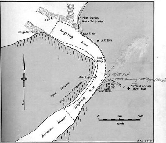
The
diagram above shows the layout of the Karumba Flying Boat Base in 1942 from the RAAF
directory Flying Boat Bases and Alighting Areas, June 1943. Unchanged since it was built four years earlier, the
base area was on the eastern bank opposite the moorings, with the jetty sticking out into
the Nroman River. The aerial masts in the base area were for the HF receivers
and the 150 ft wireless aerials about 1,000 yards inland were for the HF transmitters.
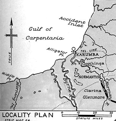
The locality diagram at left, from the same source, shows the location of Karumba at the mouth of the Norman River on the Gulf of Carpentaria.
Normanton, the major settlement in the area, was about 25 miles further inland.
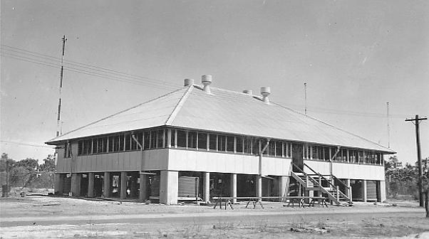
The Control Building at Karumba, below,
photographed during construction in 1938. The upper floor
contained the Aeradio room,
the Met office a sick room and the OIC's office. The building was surrounded by a wide verandah to provide shade from the tropical heat.
Below, the Barracks at Karumba with the Control Building in the background.
The Norman River with its flying boat moorings was immediately to the
right of the photo, and the Shell fuel depot was located beyond the Control
Building.
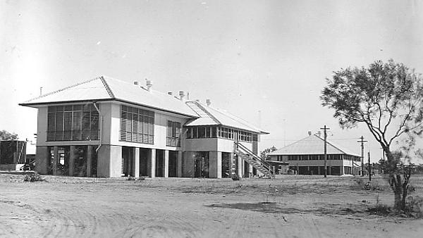
The Barracks provided dormitory sleeping accommodation for the 'men' in the near wing, and individual rooms for the 'officers' in the far wing. Additionally, the Barracks contained a kitchen at the rear
and a mess located in the central part of the building. The mess comprised of dining and relaxation areas. There was also a small canteen from which staff could
purchase daily necessities. The canteen was replenished from the monthly
supply ship, which also brought in staple foodstuffs. In the pre-war years fresh vegetables
were sent on the regular flying boatservices from Townsville or Darwin. Chickens were raised
on site and cattle were obtained from nearby stations, and killed
and butchered by the Base personnel for fresh meat.
The normal flying boat schedules meant that Karumba was principally a refuelling stop. However on occasion when an aircraft was required to make an overnight stop, the passengers would also have to be accommodated on the base. If the Barracks were full, this meant that some would sleep on the verandah of the Control Building!
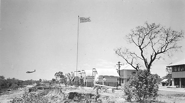
The photo
above shows an Empire flying boat coming in to land on the river mouth reach of the Norman River
at Karumba. The Civil Air Ensign flies proudly over the tents of the Commonwealth Public Works Department
workmen constructing the base in this 1938 photo. The building behind
the tree is the Barracks with, to its right, the Control Building. The river and flying boat moorings are out of sight immediately to the left of the photographer.
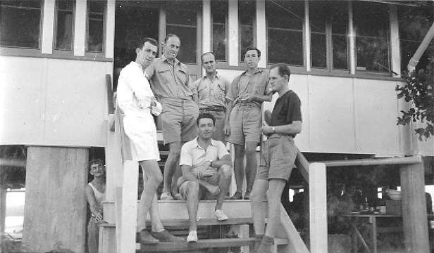
Personnel taking
part in the construction of the Karumba Flying Boat Base were photographed, above,
on the steps of the Barracks, L-R: Bob
Chamberlain, Aeradio OIC; Bob Ringrose, AWA installing engineer; Vern
Kenna, PMG engineer who brought up test gear to check the station's performance;
Vance Deering, Met Officer; Ivan Hodder, DCA Radio Inspector; Johnny Walker,
Aeradio operator. The cook is peering out from behind the stairs. Chamberlain, Walker and Deering were members of the Base staff.
One of the original Karumba Aeradio operators, John G 'Johnny' Walker recalls the early days of Karumba flying boat base:
"In August 1938 when I arrived, construction by the Dept of the Interior was under way...I was at that time employed by AWA Ltd and was so employed for another 13 months or so. I was originally appointed to Groote Eylandt. I had no idea of the geographic position of this place except I knew that AWA notices advised the magnetic variation. By following the curve on a variation chart I was able to get some idea of the location. However, at the last moment it was changed to Karumba. A day and a bit in a flying boat with an overnight stop in Townsville. On arrival there was Bob Chamberlain in charge of Aeradio and another man called Hudson whom I was to replace. Why he was moved out AWA might know. I do know that he fell through the transmitter building roof whilst it was under construction.
"There was also an AWA engineer called Ringrose. I think that apart from our Aeradio duties we were supposed to assist him. I know I was all over those 150 ft masts at the transmitter site pulling wires through conduit for the obstruction lights. I also assisted in the calibration of the Bellini-Tosi Direction Finder by marching around in the bush with a compass and an oscillator. It turned out to be a pretty good DF too. Later on - about 1940 a Mr Vern Kenna, a PMG engineer, put in the HF DF which wasn't much good and caused a doubling of staff with one on watch at the base and another at the HF DF.
"Anyway, we got another Aeradio operator in the form of Frank Brandon who, after about 12 months, was transferred to Salamaua in New Guinea and he was replaced by Wal Dempsey. Chamberlain was replaced by Eric Pearson.
"All the AWA operators joined the DCA as temporary staff on 1 September 1939 and were made permanent in 1941. The callsign was VHKA, changed later to VZKA."
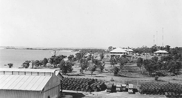
The general view, above, of the Karumba Flying Boat Base is from top of the fuel tank at the Shell fuel depot. The nearest of the buildings in the distance is the Control Building, with HF receiver antenna masts out the back near the Base's refrigeration building. The Barracks are behind the Control Building and a supply ship is tied up at the Base's jetty.
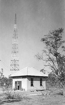
At left, the HF transmitter building and antenna mast at Karumba were located 1 mile inland from the Aeradio site on the banks of the Norman River.
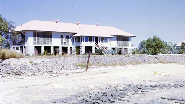
The Karumba Flying Boat Base was taken over by the RAAF in 1943 and used as a base for Catalinas of 43 Squadron. After the war the Base was returned to DCA but increased flying boat range and the change to landplane operations meant it was rarely used, although its Aeradio station continued to make a valuable contribution to operations generally. The Base finally closed in the mid-1950s. The photo of the former Barracks, below, was taken a decade later in June 1965. By this time the building
was in use as a Guest House. To the right of shot can just be seen the
former Control Building, which housed Aeradio. The
Norman River is in the foreground. The Barracks were later demolished, but the former Control Building still survives as of 2018.
(Photos: 1-4 - CAHS/Ivan Hodder collection; 5-6 - CAHS/John G Walker collection; 7-8 - CAHS/Ivan Hodder collection; 9 - Alan Fraser/Maurice Austin collection; Maps - RAAF)
Back
to the main Airports and Aerodromes
index